By Abby Kuranz, Fall 2013 Intern, CFWE
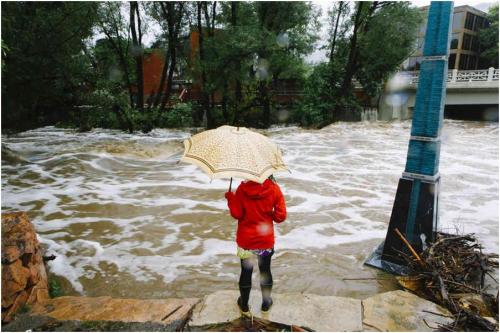
On September 9th, 2013, a low-pressure system settled over Boulder, Colorado for 5 days straight and dropped over 14 inches of precipitation, breaking daily and monthly rainfall records in Boulder County. The University of Colorado-Boulder is situated in the foothills-plains interface of the Flatirons, where Boulder Creek flows through the city center. Boulder Creek, which typically runs at about 300 cubic feet per second, maxed out at 5,000 cfs during the 5-day deluge.
Several parts of the CU-Boulder community were severely impacted by the floods: entire families were displaced, dorm rooms flooded, and campus infrastructure suffered major damage. However, students, faculty and local families have responded in-kind through a concerted effort of volunteering, fundraising, organizing high school service projects, and offering a slew of resources to aid students and faculty.
As cleanup in Boulder continues, roads are re-opened, and hiking and biking trails are rebuilt. CU-Boulder researchers are also picking up the pieces. While many researchers will need to adjust and redesign long- and short-term projects, others are using the rare opportunity to gather data for unique comparisons in an effort to accurately characterize the hydrologic event.
Picking Up the Pieces
Many researchers face setbacks with the effects of high waters on their research cites:

Environmental Studies Masters Student and INSTAAR Research Assistant, Ian Bishop, surveys his research site along South Boulder Creek at Eldorado Canyon State Park.

Many of the boulders that host Ian Bishop’s study organism, Didymo geminata (commonly known as rock snot), have shifted downstream and he will need to adjust to nearby bank failures.

Allison Louthan, who studies inter-plant interactions in the Intermountain West in the Doak Lab, could not collect seeds from her alpine study organism, Sedum lanceolatum.

Sedum lanceolatum, Allison Louthan’s study organism at CU Boulder. Louthan was trying to collect seeds from fruits for an experienct she planned on setting up next year, but the rainfall at Niwot Ridge washed out all the new seeds.
The Boulder Creek Critical Zone Observatory captured the entire flood event, and subsequent damage of their research cite, in a time-lapse video. The camera captures the influx of the water and a stream gauge washing away at Gordon Gulch, a small basin located above Boulder, CO.
Natural Experiments
Others used the flood as a opportunity to conduct a “natural experiment” to either further their current research or begin new projects:

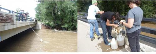
Rachel Gabor, and INSTAAR staff, Aneliya Sakaeva and Chris Jaros, collect floodwater samples from Boulder Creek.
Rachel Gabor, and helpful INSTAAR (Institute of Arctic and Alpine Research) staff, Aneliya Sakaeva and Chris Jaros, collected large samples of floodwater from Boulder Creek at two sites – 30th St. and Eben G. Fine Park. Some of the water is being tested for various water quality parameters (e.g., metals, DOM quality, etc.) to help guide decisions on further sampling. They collected a large volume (five 15-20 L carboys at 30th St. and six at Eben G. Fine Park) so they could isolate the humic material from the DOM. They have a similar sample collected during snowmelt in May 2013 which will allow them to compare the two high flow events. Their work is also part of the Boulder Creek Critical Zone Observatory.
Figuring Out What Happened and Why
One week after the flooding, John Pitlick, co-director of the Graduate Program in Hydrologic Sciences at CU-Boulder, changed the topic of his scheduled Hydrology and Water Resource Seminar to address the recent flood and the surrounding speculation.
“The hazards associated with rare but intense rainfall are well known in Colorado, and many communities along the Front Range have taken action over the years to mitigate potential damage and loss of life from rare floods. Last week we had the opportunity to observe first-hand what it is like to get half a years-worth of precipitation in one or two days, and we can begin to appreciate how the actions taken to reduce flood risks in Boulder benefited the community as a whole. Nonetheless, throughout Boulder, streets and alleys become torrents, carrying mud and rocks indiscriminately into homes and businesses. Residents in mountain towns and outlying areas have been isolated by road washouts and bridge failures. Certainly many questions will arise in the aftermath of the 2013 flood. For example, newspapers are reporting that this was a 100-yr flood. What is the basis for that estimate? How do published maps of inundation for floods with different return periods compare with the extent of flooding in 2013? Did burned areas contribute disproportionately to the floods? I don’t have complete answers to these questions, but I am happy to share results from past work (my own plus others) that helps put the 2013 Boulder Creek flood in perspective.”
The seminar, which typically hosts 20-30 graduate students and faculty each week changed venues to accommodate expected numbers for the highly anticipated talk. With standing room only, Pitlick explained that by his analysis, the flood registered somewhere between a 20-year to 50-year event.
When media told use the event was a “biblical,” “100-year,” or “1000-year” flood, CU-Boulder and the Cooperative Institute for Research in Environmental Sciences (CIRES) responded by assembling a panel of science experts to discuss if and how weather and climate played a role in the flood event. Western Water Assessment, an applied research program that addresses societal vulnerabilities related to climate, also put together a preliminary assessment to address whether or not the flood was human-induced or if it was on track with Colorado’s historical hydrologic cycle:
“If we query the NOAA 20th-century reanalysis dataset—which blends historic surface and upper observations in a numerical weather model to create detailed and consistent images of past atmospheric circulation—we can do a quick comparison of the setup for the 1938 event with that for 2013. What we find is that the patterns were remarkably similar: a low pressure area to the west that drew moisture from the south and east, and blocking highs that kept the moisture flow pinned in place for several days.
While research is ongoing at CIRES to investigate how the 2013 flood may have been influenced by human-caused climate change, the 1938 flood tells us that the climate system was capable of producing that type of flood event—in September, no less—under more “natural” atmospheric conditions.”
While the flooding in Boulder is sobering reminder of the power of water and its intricate connection to land-use, it is also an opportunity to learn, evaluate, and adapt.
Related articles
- CU-Boulder Students Help Residents Clean Up After The Colorado Floods (huffingtonpost.com)


 Print
Print
Reblogged this on Coyote Gulch.
It will be very interesting to note effects of the flood on riparian and stream ecosystems around the Boulder area in the coming years. Additionally, it will be a challenging for researchers to adapt to significant change in their research sites.
One of the reasons why the Boulder flood was so devastating may have been the flood plain boundaries. Boulder’s flood plain boundaries had not been updated since the 100 year flood during the 20th century. Considering this, it is not difficult to understand why so many people were effected outside of the flood plain. Since the recent flood, Boulder county has been producing new boundaries for the flood plain in order to better prepare for floods in the future (however unlikely a flood like this is to happen again, preparation is always beneficial). With more accurate flood plain boundaries, residents will be better prepared to for evacuation and safety precautions if another downpour does happen again in the near future.
Good point Adrian. I am happy that everyone in your house remained safe and were not forced to evacuate. Nice job with your comment.
How fast the creek was moving is crazy and the damage done to areas that are next to the creek were extremely devastated. I heard one statistic that there was almost as much rain in those five days as there was it the enitre year last year. One area that was impacted was Boulder High School. just driving past you can see the damage to the softball field and the erosion around it. My students and families were devastated by the flood, ruining entires basements. One of my friends was forced to find a place to live for over a month. Some landlords weren’t happy nor were the tenants forced to live in hotels or couch surfing. The city of Boulder needs to find a solution to help prevent this from happening again and the devastated areas around the creek and the businesses that were completely destroyed like Boulder Ski Deals.
How fast the creek was moving is crazy and the damage done to areas that are next to the creek were extremely devastated. I heard one statistic that there was almost as much rain in those five days as there was it the entire year last year. One area that was impacted was Boulder High School. just driving past you can see the damage to the softball field and the erosion around it. My students and families were devastated by the flood, ruining entires basements. One of my friends was forced to find a place to live for over a month. Some landlords weren’t happy nor were the tenants forced to live in hotels or couch surfing. The city of Boulder needs to find a solution to help prevent this from happening again and the devastated areas around the creek and the businesses that were completely destroyed like Boulder Ski Deals.
I have been going down to the Boulder Creek now for three years and I would have never thought that it would have been possible for the water to flow that fast. I had never personally been in a situation like this before and I was amazed of how much damage was done to the town of Boulder. One of my biggest long term questions was on the ecosystem of the creek and the surrounding area because I am an avid fly fisherman. Two weeks ago I went up the creek to see if I was still able to fish and to my pleasant surprise there were still an abundant amount of fish in the creek but the destruction in the canyon was much worse than I thought it would be.
Being present in Boulder amidst the “100 year flood”, was very frightening but also very interesting at the same time. As an ENVS student I know the importance of ecological studies after a natural disturbance such as this flood. Although many studies, as said above, were destroyed, the flood opens up plenty more opportunities of studies surrounding the Boulder Creek, and many other regions of flooding. It is rare, especially in the Boulder Creek, that research pertaining to restoration ecology are able to be done.
From the flooding on campus to the extreme amounts of damage done surrounding Boulder creek it was evident that the community as a whole was not 100% prepared for such an event. Outdated systems need to be modified to prevent such devastation from occurring yet again. If the scientists are right that this particular flooding could happen within the next 20-50 years instead of every 100-1000 years then it is imperative that the Boulder community take the necessary steps to minimize future damage.
As somebody who lived through the Boulder flood, all I associated it with was negative feelings. After reading this, I was able to see that people were using the flood as an opportunity for natural experiments which could eventually benefit society. It was also very interesting to learn how rare it was for these weather conditions to occur, and that we received half of a years worth of precipitation in just two days! I think it is important for us to use this flood as a learning experience in order to find new ways to adapt if this situation were to occur again.
Just saying thanks wouldn’t just be enough, for the fantastic fluency in your writing.