It’s uncomfortable to spend a night without water. It’s even more uncomfortable if you’re miles from civilization on the Colorado Trail with no certainty about where to find the next drop.
That’s the situation hikers Heidi Steltzer and Karin Ahern found themselves in after several hoped-for water sources turned up dry in late July. They’re not alone: Water supplies along stretches of Colorado’s namesake trail are under more stress as the state faces rising temperatures and prolonged drought.
This means that even guidebook-toting, experienced hikers can find their well-laid plans derailed by the unexpected. That’s a lesson Ahern and Steltzer learned well.
“There was a creek (in the guidebook), and I was like, let’s get there,” Ahern said, referring to the official Colorado Trail pocket guidebook. “It was completely dry. My heart sank.”
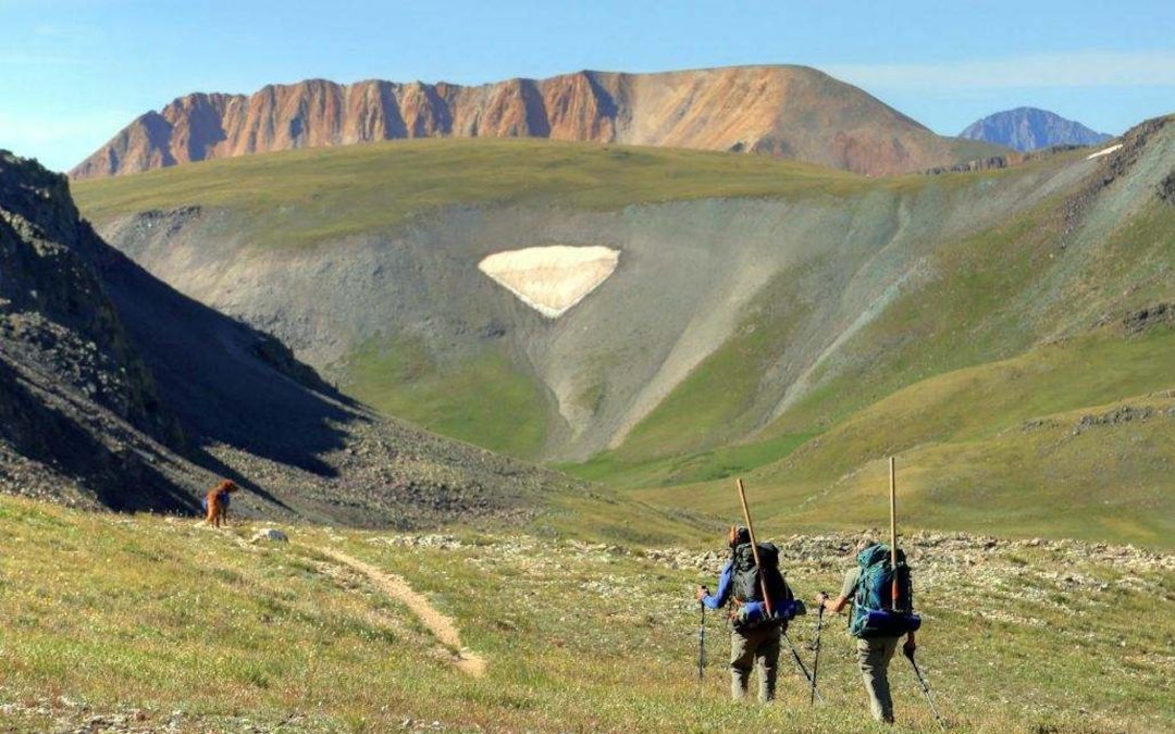
The Colorado Trail is one of the nation’s premiere long-distance trails. It heads southwest from Denver, passing through five river systems, spanning nearly 90,000 vertical feet and running over 500 miles before ending in Durango.

Ambitious, long-distance hikers have to carefully time their journey on the trail, which typically takes four to six weeks to complete. The start time varies depending on when snow melts in June. Some water sources dry up by July and August, and early season snow storms can start in September.
Since 1988, at least 5,500 people have completed the entire trail, including 499 in 2023, according to the Colorado Trail Foundation.
But water isn’t always where it used to be, when it used to be there. Climate scientists are tracking long-term changes, like temperature increases, precipitation declines and even a snowpack that seems to be shrinking and melting earlier in the summer.
These changes impact more than the state’s namesake trail: The snowpack is Colorado’s primary water source, and snow on the Western Slope feeds the seven-state Colorado River Basin. Less snow and earlier melt can strain water resources for farmers, fishing guides, rafting companies and communities, especially in the late summer.
For trail users, it means that the long-standing norms outlined in blogs and books don’t always apply. Or, instead of leaving technology behind, they’re relying on phone apps for real-time updates about trail conditions.
It means planning for more uncertainty.
Running out of water
When Steltzer, a spiritually minded environmental scientist based in Durango, ran out of water on the Colorado Trail, her first thought was to pray. Her second was that it probably had something to do with climate change.
“We were above 12,000 feet. That’s high. If the snow is going to stick around anywhere, it’s going to be two places: one, the subalpine forests and it’s going to be at higher elevations,” said Steltzer, who specializes in alpine environments.
Steltzer and her hiking buddy Ahern set out from the San Luis Trailhead north of Creede in late July. Ahern, a Denver Public Schools speech pathologist, had been tackling sections of the trail for three years. This summer, her fourth, she aimed to hike her last stretch from Creede to Durango, and she was excited to have Steltzer join her for a few days.
On the first day, the pair didn’t make it as far as planned and had to use their packed water to “dry camp” instead of camping near a lake. The next day, they refilled at Spring Creek Pass. Then the next potential water source — marked with a half cup in the official Colorado Trail guidebook — turned up dry. So did the next one. And the next.
By the time they camped under a cellphone tower, Steltzer was out of water, and Ahern had 3 cups left. Over a dinner of snack bars, they planned for the next day when they were supposed to climb the highest point on the entire trail, Coney Summit.
They could either keep going and take a chance on the next possible water source, which could also be dry, or hike back to Spring Creek. Remembering that night, Ahern said she was mad and disappointed with herself: I should have known better, she said.
“Heidi, being her, was like, it’s climate change,” Ahern said. “I don’t know the answer to that. Ten years ago, was there still going to be water in that creek? I have no idea.”
Water in the high country
Steltzer is not the only one noticing drying in the area. Trail adopters Jodie Petersen and Dave Peters have too.
On some sections of the trail, hikers pass water every 15 minutes, and trail users are well aware of certain segments without any water sources near the trail, they said. But the couple has seen changes in an 11-mile stretch of the trail, just west of Coney Summit, where they have been doing maintenance work since 2007.
“In 30 years time, we’ve definitely noticed a difference in terms of the amount of water we see out there that’s available to thru-hikers,” Petersen said about their adopted section. “I don’t think there’s any doubt there’s decreased water up there.”
Researchers have noticed the snowpack and some streams are shrinking by small amounts each year. They’re tracking larger temperature increases and drier summers in southwestern Colorado, where much of the trail is located, than elsewhere in the state.
Summer temperatures increased by nearly 3 degrees between 1980 and 2022 in southwestern Colorado, said Peter Goble, a climatologist with the Colorado Climate Center at Colorado State University. The average summer between 2001 and 2022 was 11% drier than the summers between 1951 and 2000.
Statewide, summers are about 2.5 degrees hotter and 6% drier, over the same time periods, Goble said.
“Climate models are kind of all over the map in terms of whether or not that trend will continue or even reverse,” Goble said. “2024 was certainly a wet summer for that area, so the year-to-year variation continues to be a very important factor.”
Finding water on the trail

After a coffeeless morning, Steltzer and Ahern ended up finding water in an unexpected way.
The pair chose to continue toward the next potential water source, but before they got there, Steltzer noticed a pickup truck coming up the trail along the grassy mesa. A crew from Gunnison Trails was in the backcountry to do maintenance — with jugs of cold water and snacks in tow. Steltzer hopped in the cab to catch up to Ahern, who had walked ahead.
“It was like a scene from a movie. (Heidi) was like, ‘We have water!’ with half of her body hanging out of the truck,” Ahern said.
Every hiker, biker and horsepacker on the Colorado Trail will have different stories about how they did, and didn’t, find water.
Connie Wian, another trail adopter with the Colorado Trail Foundation, maintains a stretch next to a river and said her problem is when there’s so much runoff that it impacts the trail.
Jerry Brown, a surveyor who helped create the first detailed maps for the foundation’s guidebook, has hiked it seven times. He’s noticed some drier conditions, but with good planning, experienced hikers will be fine, he said.
“If you come to a good water source, do not walk past it unless you know you’re in range of another water source,” Brown said.
 Print
Print