The launching of any multi-day river trip is a scene of controlled chaos: last-minute gear checks, piles of dry bags, ammo cans and food being loaded onto boats, campsite selection and group safety talks. No matter the river, it’s a ritual I’ve experienced dozens of times. In June 2014, I was amid this chaos as I stood on the banks of the Yampa River in Dinosaur National Monument in northwestern Colorado with a collection of others who also had the good fortune of being guests on the Friends of the Yampa annual Yampa River Awareness Project float.
The purpose of this trip was more than just recreation and camaraderie. We were together to experience a river with a largely natural hydrograph, or flow pattern, which peaks sharply in May or June and steadily drops throughout the summer. On this day, the river was at its peak, and the water rushed by cold and clear. In three months’ time, the river would be so low you could almost walk across it. Our goal was to understand the power of this wild river, and to discuss the reasons why it is unique and deserves protection.

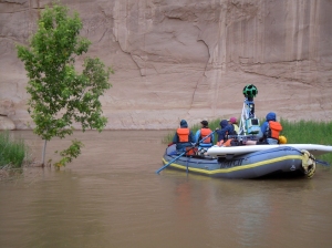
The Google Trekker camera floats to the confluence of the Yampa and Green rivers in northwestern Colorado with CFWE Executive Director Nicole Seltzer and others.
As we were to find out, there was also another purpose for the trip. The big, green alien disco ball lying in the grass next to me was the result of a partnership between Google Maps and American Rivers to make the Yampa the second river to be photographed in “street view.” The first was the Colorado River through the Grand Canyon, filmed in 2013. Once filmed, edited and uploaded, anyone would be able to log on and follow the Yampa’s 72-mile course through Dinosaur in a 360-degree panorama.
After signing confidentiality agreements, we were given a crash course in how the “trekker” worked. The camera, made up of several individual lenses that snap photos just seconds apart while on the river, was to be mounted on a raft to record the scenery and fun rapids, as well as strapped to a specially designed backpack and hauled up side canyon hikes by Devin Doston, American Rivers’ national associate director of communications. While our trip would be memorialized forever on Google Maps, the editing process would automatically blur our faces and any identifying information. We were discouraged from displaying any antics that Devin would have to edit out later, though you know it crossed our minds!
Yesterday, just over seven months since Dotson and the rest of our group spent four amazing days floating with the trekker through Dinosaur, American Rivers and Google Maps released Yampa River Street View to the public. I have had fun zooming down the river, looking for glimpses of my blue paddle jacket. But finding myself on Google Maps is minor compared to the impact this project could have for the river and those who want to learn about it. “We are excited and hopeful that this new tool will bring increased awareness of the exceptional Yampa River. And we are positive that these ‘virtual visits’ to the Yampa will lead to more people wanting to help protect this magical place,” said Soren Jespersen, board president of Friends of the Yampa.

CLICK PHOTO ABOVE FOR VIDEO IN A NEW WINDOW! CFWE executive director Nicole Seltzer was on the raft with the Google Trekker the day the group ran Warm Springs rapid. The run, which captured footage for the new Yampa River Street View (shown above), was itself documented in this great video from a crew member on shore. CFWE’s content program manager, Jayla Poppleton, was on board the paddle raft that ran the rapid just in front of the trekker.
Rafting the Yampa River through Dinosaur National Monument is a lifetime highlight for whitewater enthusiasts. Of the more than 6,000 applicants for a permit in 2014, only 5 percent actually got their feet wet on this stretch of river. Between the Friends of the Yampa trip and a friend’s private trip, I was fortunate to have experienced back-to-back trips in June 2014. River karma dictates that I probably won’t go again for a number of years. I look forward to the day when I can once again explore this special place, but in the meantime, I can reminisce about the journey on Google Maps.
To explore Yampa River Street View, visit http://www.americanrivers.org/yampa


 Print
Print
Reblogged this on Coyote Gulch.