This interview, which first appeared in the Rocky Mountain Farmers Union (RMFU) newsletter, will be shared as a three-part series here on the blog exploring groundwater and compact compliance in the Republican River Basin and the work of the Republican River Water Conservation District. Read the second post in the series here and the third post here.
 RMFU director of communications, Bob Kjelland, visited with Timothy Pautler. Pautler has lived on the Pautler Family Farm his entire life. He is the third generation to operate the property his grandfather purchased in the early 1900s. He and his brother formed a partnership in 1976, which continues today. Together they use a three-year rotation of wheat, corn and summer fallow. Due to the decline in the aquifer, they have retired six pivots on the family property and eight on rented ground. Pautler is active in his community. He was on the Burlington Conservation Board from 1985 to 2001 during which the farm bill reintroduced the Conservation Reserve Program. He chaired the Resolutions Committee for the Colorado Association of Conservations Districts. And he served on the Colorado State Soil Conservation Board from 1999 through 2001. Since 1992 he has been on the Plains Ground Water Management District and represents the Kit Carson County Commissioners on the Republican River Water Conservation District (RRWCD). He is a member of the Colorado Master Irrigator Project Advisory Committee. Timothy is a graduate of Stratton High School. He married Elizabeth Stegman in 1975. They have three daughters and seven grandchildren. Here are Timothy’s responses to questions about the district.
How did you get involved in the Water Conservation District?
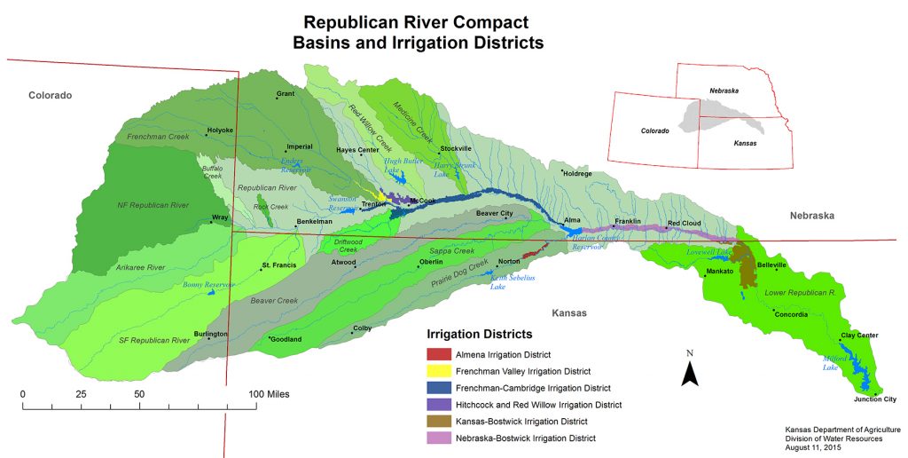
Simultaneously with the settlement of the Arkansas River Compact dispute between Colorado and Kansas, the State of Colorado was in litigation with Kansas and Nebraska on the Republican River Compact. Colorado decided to approach the defense of this conflict differently than the Arkansas, so through legislation, the state created an entity to assist in achieving compliance and in August of 2004 the Republican River Water Conservation District was formed.
The board members represented, at the time, seven counties, seven Ground Water Management Districts, and one member from the Colorado Ground Water Commission. As a result of encouragement from local folks, I put my name in for consideration to represent the Kit Carson County Commissioners, and was subsequently appointed.
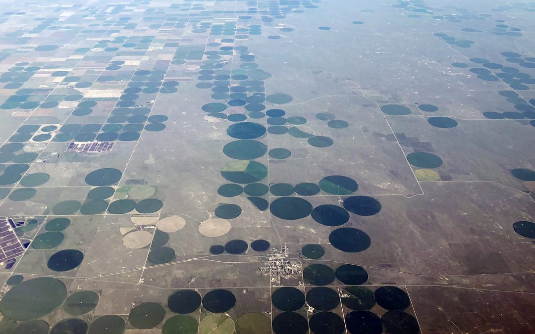
 My understanding of what was happening to the Ogallala Aquifer in my area of the basin was the driving force behind my desire to participate in the decision to assist the state efforts. The economy that was created by state action to effectively allow the mining of the aquifer and the resulting decline of the water level was a concern.
Note: In 2019, the boundary for the RRWCD was expanded to include all the irrigated acres that are actually contributing to the Compact issue. This change affected folks in the southeast part of Kit Carson County and the northern part of Cheyenne County and in the East Cheyenne Ground Water Management District. This change created two more board member positions, representing those two new entities. This expansion included approximately 45,000 new irrigated acres to the RRWCD fee assessment.
What Does the Republican Water Conservation District do?
Simply put, we were created to assist the State of Colorado in achieving compliance on the Republican River Compact that was signed in 1942. In the beginning, the state told us that if we retired 30,000 acres from irrigation, we would be in compliance. So that was the direction that we set out. To fund the required budget that was going to be needed, the RRWCD assessed all irrigated acres a fee of $5.50 per acre. At that point in time, the basin did not have meters on any of the wells, so a per-acre charge was really our only option and was easy to do using the county assessors’ records. We worked with the Natural Resources Conservation Service (NRCS) and the Farm Service Agency to create programs that would financially compensate producers for voluntarily retiring some of their irrigated lands. We use funds from NRCS through their Environmental Quality Incentive Program (EQIP) and funds from FSA through its Conservation Reserve Enhancement Program (CREP). The fee assessment revenue was used as matching funds to make these programs possible.
Over time we have also been actively involved with purchasing surface water rights on the Arikaree and the North and South Forks of the Republican. We were involved with the Pioneer and Laird ditch rights. When they were purchased by the Yuma County Water Authority (YCWA), the RRWCD leased those rights from the YCWA for $5 million for 20 years. This transaction leaves water in the North Fork of the Republican and is accounted for at the gauging station located just east of Wray. We are continually working with surface water folks in order to acquire their rights and this practice is ongoing. Because of the way surface water irrigation is accounted for under the Compact, the retirement of these water rights is very helpful in achieving compliance.
I would be remiss if I did not mention that our leadership group was instrumental in pulling the wagon in the right direction. The 15-member board works together to make everyone understand what was at stake. This was a basinwide issue. The health of the basin as a whole had to be the first and foremost concern. The entities that we all represent and our personal wants had to be absolutely last on the priority list.
As we moved through time, the collective efforts started to bring results for the basin. We were well on our way to retiring the 30,000 acres of irrigated land. The programs were working rather smoothly, and the process was a success.
But then our General Manager Stan Murphy and our engineer Jim Slattery started to look at the numbers and realized that the retirement of acres alone was not going to get us where we needed to be in order to be in compliance. The acreage retirements were coming so far from the three streams—the North Fork, the Arikaree, and the South Fork—to achieve our goal. The retirements were still a good concept as leaving water in the ground is always a positive. But the lagged depletion effect that existed in the aquifer was not allowing the impact of acreage retirement to result in immediate stream flow. The lagged depletion describes the impacts that distant well pumping has on stream flow. As a result of the lag effect, the impact of present day pumping will have negative effects for 30 to 50 years according to the engineers, even though a well has been retired. The effects that those distant retired wells created, prior to retirement, continued to haunt the long term goals of the RRWCD.
In 2002, the Republican River settlement had been signed. The Final Settlement Stipulation (FSS) agreed that Kansas, Nebraska and Colorado would not fight about water use—that was in the past—but only work toward achieving future compliance with the compact that allocates how much water each state is entitled to use. As part of the Final Settlement Stipulation between the three states, the accounting for all states started at zero; The stipulation also allowed that any one of the states could use a pipeline to get additional water to the river in order to get into compliance.
So that became the next challenge for the board. Where do we get enough water to make a difference? We started looking at an exhausting list of possibilities, including the Dakota formation below the Ogallala, areas of the basin that were under appropriated, and imports from the South Platte. At the time, we left no stone unturned. Every idea had issues that introduced new challenges. The Dakota was going to be too salty and too costly to bring to the surface and would not yield enough water. The unappropriated area was going to require too many easements and a pipeline of extreme length. The South Platte was too expensive. In the end, we were able to make a deal with one family. Their water rights were located northeast of Wray. This area of the basin has absolutely the greatest amount of saturated thickness. It is far enough away from the North Fork to minimize effects on streamflow, yet close enough that the pipeline length of 13 miles was a doable deal. We were able to acquire about 13,500 acre-feet of Historical Consumptive Use from 62 permits, all in a block.
The Colorado Ground Water Commission then approved our application, allowing us to consolidate the 62 existing wells into 15 to be used for Compact Compliance, without any injury to surrounding water rights. Along with the water purchase, we negotiated easements from the landowners for our pipeline route. The cost of the water and easements was $50 million. The engineers designed a pipeline system that cost $20 million.
All through this process, we were hosting informational meetings with the public, keeping people informed of our intentions. A $70 million project was not an easy sell, especially when you factor in our new budget requirements. The $5.50 per acre assessment needed to go to $14.50. This created a budget of $7 million. We were able to secure a loan from the Colorado Water Conservation Board for the $60 million balance at an interest rate of 2 percent. The 20-year note will be paid off in 2028. The public acceptance of the concept came with a lot of questions. As everyone’s understanding of the entire Compact issue increased, so did their support.
Learn more about Colorado Colorado’s interstate compacts in Water Education Colorado’s Citizen’s Guide to Colorado’s Interstate Compacts and learn about groundwater across the state through WEco’s new Citizen’s Guide to Colorado Groundwater.
 Print
Print